| Green Road | |
|---|---|
| Type | Road |
| Continent | Tamriel |
| Province | Cyrodiil |
| Region | Nibenay |
| Appears in | Oblivion |
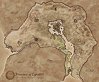
The Green Road is one of the major colored roads of Cyrodiil. It runs from the Red Ring Road in the Heartlands and travels south through the Great Forest and along the western Niben River until it reaches Leyawiin on the Topal Bay. Along the way, it passes around Bravil and the Larsius River.[1] Some maps depict this road traveling directly south into Elsweyr where it reaches Riverhold.[2][3][Note 1]
For an unspecified amount of time, the western Lower Niben, which included adjacent portions of the Green Road, was part of Elsweyr. The border has long been disputed between Elsweyr and County Leyawiin in southern Cyrodiil. It was not until the late Third Era was an agreement settled between leaders at the time, the Mane and Count Marius Caro. This decision was not taken lightly by some Khajiiti groups, namely the Renrijra Krin warriors, who started a rebellious cause to take the land back.[4][5] For travelers and caravans, the Green Road south of the Niben Bay had become hostile territory.[6]
NotesEdit
See AlsoEdit
- For game-specific information, see the Oblivion article.
ReferencesEdit
- ^ Green Road in Oblivion
- ^ Map of the Imperial Province – The Elder Scrolls: Arena
- ^ Map of Elsweyr – The Elder Scrolls: Arena
- ^ Pocket Guide to the Empire, 3rd Edition: Sugar and Blood: the Cats of the South — Imperial Geographical Society, 3E 432
- ^ Ahzirr Traajijazeri — Anonymous
- ^ Guide to Leyawiin — Alessia Ottus
- ^ Map of Cyrodiil – The Elder Scrolls IV: Oblivion
- ^ Cyrodiil in ESO
- ^ Reaper's March in ESO
